
The zero entry mine is closer than you think as autonomy is redefining safety, productivity and possibility underground


, , , , , , , , , , , , ,
, , ,
, , , , , ,
The future of underground mining could mean no one sets foot underground at all - a zero-entry mine powered by autonomy, interoperability, and constantly updated digital twins.
Speaking with The Rock Wrangler, Stefan Hrabar, Co-Founder and Chief Strategy Officer at Emesent, says that vision is more than a thought experiment. It is the logical end point of a career spent bridging robotics research and mining practice, and it is already taking shape in the way mines capture and use data today.
From CSIRO to commercialisation
Stefan’s journey began in robotics labs, where he specialised in vision-based navigation and collision avoidance for unmanned aerial vehicles. That work eventually led to the development of Hovermap, a lightweight LiDAR payload and autonomy engine first prototyped at CSIRO. By 2018, Stefan and co-founder Farid Kendoul spun the technology into Emesent, building a company around the core challenge of mapping GPS-denied environments.
“Autonomy is the key ingredient,” Stefan says.
“If you can safely navigate drones or robotic platforms in areas where GPS does not work, you can capture data in places that were previously inaccessible - and you can do it without putting people at risk.”

Stefan Hrabrar
Shadowless stopes and safer scans
In practice, Hovermap has transformed one of mining’s most dangerous and data-poor workflows: stope mapping. Where once surveyors stood on the edge of a bund with a cavity monitoring system (CMS) mounted on a pole, now a Hovermap-equipped drone can fly into the void autonomously, capturing a complete, shadowless point cloud.
“Previously you only got data from one vantage point, with a lot of guesswork filling in the gaps,” Stefan explains. “Now the drone flies inside the stope, mapping every corner. You have got accurate volumes, you can pick up loose rock, you can reconcile against design, and all of that happens without anyone standing in harm’s way.”
The shift has been significant. Mines report not only safer conditions but also faster reconciliation - sometimes cutting workflows by up to 75 percent. For planners and geotechs, richer datasets mean fewer surprises and more confident decisions.

Safety in two layers
Stefan frames Hovermap’s contribution to safety in two distinct layers. The first is obvious: autonomy keeps people out of brows, drawpoints, and void edges. But the second is more subtle and arguably more powerful.
“Because you are getting better insights about what is happening underground, you can identify instabilities earlier,” he says.
“Convergence monitoring and change detection give you a kind of early warning system. It is not just keeping people away from hazards - it is reducing the chance those hazards develop into incidents in the first place.”
Autonomy and the AI wave
Autonomy at Emesent is powered by Cortex, the software “brain” that uses LiDAR data for simultaneous localisation and mapping (SLAM), obstacle detection, and path planning. But Stefan sees the real opportunity in what comes after the scan.
“We have been doing AI in robotics for twenty years, but what excites me now is applying AI to the data itself,” he says. “Post-processing, analytics, and insights - that is where AI can really speed up the time it takes from capture to decision. The goal is to get actionable information into the hands of operators and engineers as quickly as possible.”
Already, Hovermap units process point clouds onboard, allowing operators to preview results in the field without waiting to return to surface. Future releases aim to further automate interpretation, from geological structure detection to automated compliance reporting.
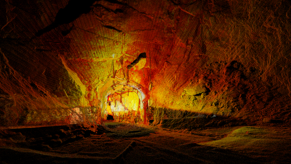
A Hovermap-generated LiDAR point cloud reveals the full geometry and structural detail of an underground tunnel, capturing areas invisible to traditional methods.
Incremental adoption, practical wins
Despite the technical sophistication, Stefan is quick to stress that adoption does not require a wholesale overhaul of workflows.
“We were not asking surveyors to change everything,” he says. “Instead of using a CMS, they used a drone. The rest of their workflow stayed the same. That meant they could see the benefits straight away - better data, safer work - without disruption. It is about finding those no-brainer use cases where the technology just makes sense.”
That incremental approach has helped overcome cultural barriers in an industry often sceptical of new systems. Mines can start with a single use case, such as stope mapping, and then extend into old workings, convergence monitoring, or vehicle-mounted scanning once confidence grows.
Toward the zero-entry mine
Looking ahead, Stefan returns to the idea of the zero-entry mine, a concept that resonates strongly with ESG and operational leaders alike.
“Most of the ventilation and cooling in a mine exists for people,” he notes. “If you remove people from underground, you can drastically cut power consumption. That is a huge environmental and cost benefit. On top of that, you can start mining orebodies that are impossible today - deposits that are too deep, too hot, or too geotechnically risky for human entry.”
Achieving that vision requires more than one company’s product. Stefan emphasises the need for open standards and interoperability between different OEMs and systems.
“You are going to have multiple systems from different suppliers all working together, ideally sharing data and coordinating,” he says. “The output from Hovermap has to flow seamlessly into a single source of truth - a digital twin that is constantly updated. That digital twin is not just for planning and analytics. It is what will enable autonomous navigation itself, the way GPS underpins vehicles above ground.”

Interoperability and digital twins
The idea of an updated, unified digital twin sits at the heart of Emesent’s roadmap. Data from Hovermap must slot directly into established mine planning tools like Deswik, Maptek, or Pointerra3D, while also feeding into real-time operational dashboards.
“That interoperability is critical,” Stefan says. “You do not want silos of data. You want every system - from survey to production to geotech - operating off the same picture of the mine. That is what will make autonomous operations viable at scale.”
Engineering the future mine workforce
The prospect of a zero-entry mine also raises questions about the workforce of the future. If surveyors and geotechs are no longer underground, what will their roles look like? Stefan believes autonomy does not eliminate these jobs but shifts their focus.
“There will still be a need for people with domain knowledge,” he says. “But instead of spending hours collecting data in hazardous conditions, they will be interpreting richer datasets, making higher-level decisions, and validating AI outputs. It is about elevating the role rather than replacing it.”
Case studies and proof points
Mines already using Hovermap report tangible benefits. At Glencore’s Mount Isa operations, surveyors praised the system for eliminating shadows and producing “true void volumes” in monthly reconciliation scans. At Barrick’s Bulyanhulu mine, Hovermap captured data that a traditional boom scan never could, improving volume accuracy and reconciliation confidence.
“These are not pilot projects anymore,” Stefan notes. “They are everyday workflows. And the more mines use the technology, the more they realise what else it can do.”
Challenges still ahead
Even as autonomy becomes more robust, challenges remain. Dust, thin wires, and mesh can confuse sensors, and while Cortex’s filtering algorithms are improving, Stefan admits there are still edge cases. Long scans in declines can drift, requiring careful georeferencing with ground control points.
“Autonomy does not remove the need for good survey practice,” he cautions. “You still need robust workflows, controls, and trained operators. But the tools are getting better every year, and the trajectory is clear.”
The road ahead
So what does Stefan see shaping the next decade of mining technology?
“Improved autonomy in harsher conditions, yes,” he says. “But the bigger picture is systems that work together - open standards, data interoperability, digital twins. That is what will unlock zero-entry mining. It is not just about flying a drone better. It is about creating a living, shared model of the mine that every decision-maker can use.”
For an industry under pressure to improve safety, cut costs, and reduce environmental impacts, that vision has obvious appeal.
As Stefan puts it: “What you cannot measure you cannot manage. With autonomy and rich data capture, we can measure more, measure better, and manage mines in ways that were unthinkable before.”