
Landscapes don’t lie — CSIRO’s new tool helps geos spot what the soil’s really saying (and what your last survey probably missed)

, , , , , , , , , , , , , ,
, , , , , , , ,
, , , , , ,
In the ever-evolving field of mineral exploration, the challenge of interpreting surface geochemical data in complex terrains has long limited early-stage targeting success. But a new tool from Australia’s national science agency is turning that challenge into opportunity—offering a streamlined, data-driven method to classify landscapes and evaluate geochemical outliers with unprecedented clarity.
Developed by the CSIRO, LandScape+® is a browser-based application designed for exploration geologists working across Australia. It applies machine learning to publicly available spatial data, allowing users to generate detailed ‘landscape type’ maps that bring powerful context to geochemical surveys. The result? A faster, more accessible way to spot anomalies, reduce false positives, and unlock overlooked prospects.
“We’re not replacing expert interpretation,” said Dr Anicia Henne, a senior research scientist at CSIRO and one of the tool’s lead developers. “But what LandScape+ does is make first-pass geochemical exploration more accessible, simpler, and faster—particularly for teams working in underexplored or variably covered terrains.”

Anicia was speaking to an audience of mineral exploration professionals during a national webinar hosted by the Association of Mining and Exploration Companies (AMEC) in June 2025. The session offered a live demonstration of the software’s capabilities, drawing on real case studies and recent field trials. For many in attendance, the technology represented a shift in how surface geochemistry can be understood—and more importantly, acted upon.
The Context Problem
“Exploration teams are often looking for patterns in noisy data,” Anicia explained. “But those patterns can be misleading if you don’t have landscape context. You might be comparing a residual soil profile to a transported sediment environment and interpreting them as equivalent—when they’re not.”
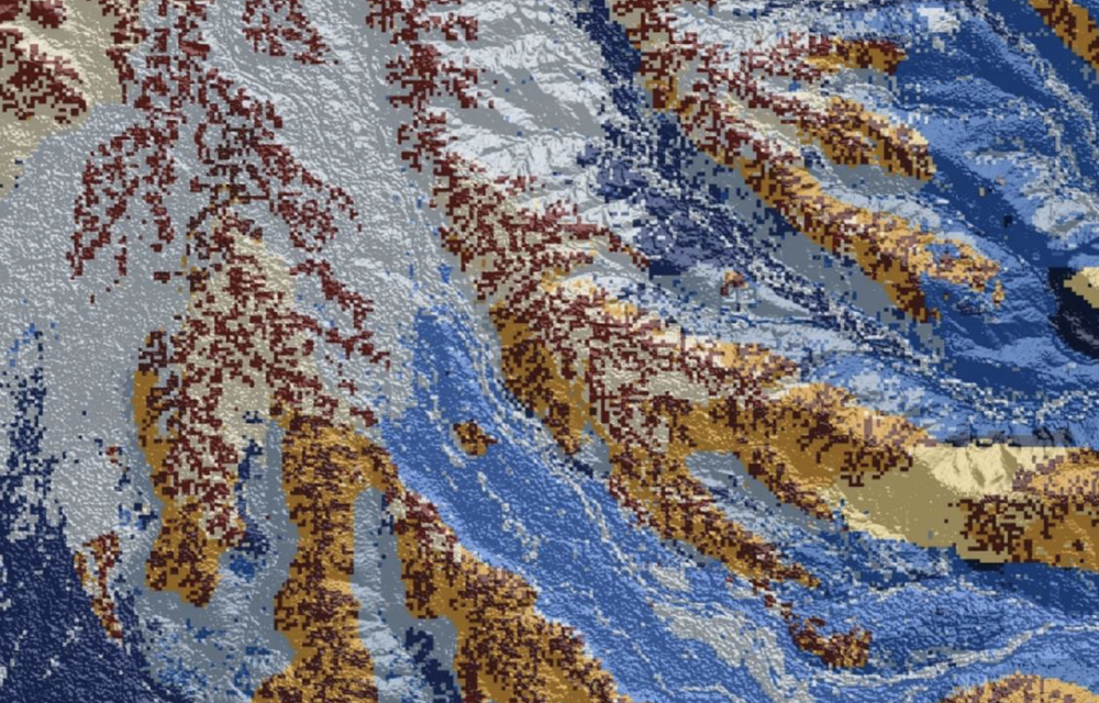
This is the core challenge LandScape+ was designed to address. Traditional soil surveys often mask subtle but significant geochemical signatures because they group data from geologically disparate settings into a single dataset. LandScape+ solves this by segmenting a model area into discrete landscape types, using a combination of remote sensing data and digital elevation models to identify proxies for regolith variation.
The underlying data includes radiometric signatures (potassium, thorium, uranium), Sentinel-2 spectral indices, terrain morphology from DEMs, and a calculated index known as MRVBF (Multi-Resolution Valley Bottom Flatness), which estimates relative depth of cover.
These inputs are processed through an unsupervised machine learning workflow. First, dimensionality reduction is performed using UMAP, a technique that clusters similar pixels in a three-dimensional feature space. Then, clustering algorithms are applied to generate between four and sixteen “landscape types”—mapped at a 30-metre resolution across the defined area.
“None of this uses your geochemistry in the modelling stage,” Anicia clarified. “That’s important. It’s a landscape model first. Once your landscape types are defined, only then do you bring in your soil data and evaluate geochemical outliers within each landscape bucket.”
A Powerful Filter
For practitioners, the real power of LandScape+ lies in what happens next. By comparing each geochemical sample to its peers within the same landscape type—not across the whole tenement—users can detect subtle anomalies that may otherwise be lost in the noise.
“This lets you filter out false positives in geochemically ‘hot’ landscape types, and flag real outliers in otherwise quiet zones,” said Anicia. “The best targets often aren’t the loudest—they’re the ones that stand out in the right context.”
One of the most compelling case studies shared during the webinar came from New South Wales. In a trial involving nearly 11,000 samples across known polymetallic prospects—Wagga Tank and Southern Nights—traditional interpretation had overlooked several key geochemical indicators. When the data was rerun through LandScape+, new outliers emerged in previously ignored terrain types, pointing directly toward mineralisation.
“What’s striking is that these weren’t just theoretical improvements,” said Anicia. “They actually realigned interpretation with reality. And all without having to visit the site first.”
Field-Tested and Iterated
While the modelling is complex, the interface is intentionally user-friendly. Designed to work in a standard web browser, LandScape+ guides users through uploading data, defining their model area, applying masks (e.g., to exclude roads or mine infrastructure), and running the model.
Licences allow for three model runs per area (up to 2,000 km²) and one year of access. Results can be downloaded as GeoTIFFs, shapefiles, and tabular reports—and users can share projects with teammates or consultants at no extra cost.
“There’s a lot you can do just by dragging in your soil survey and defining your boundary,” Anicia said. “We wanted to build something that small teams could use without needing a full-time GIS specialist.”
That accessibility has been a key focus throughout development. Over the past four years, the CSIRO team has refined the software in partnership with geological surveys, consultants, and SMEs. Iterative feedback has shaped everything from clustering logic to user experience.
“It’s been co-designed with the industry that’s actually going to use it,” Anicia said. “We tested it with explorers on the ground and adapted the tool based on how they interpreted results.”
Not a Magic Wand
Despite its promise, LandScape+ comes with caveats. Anicia was quick to point out its limitations.
“It’s a tool, not a magic wand,” she said. “It relies on the quality of your input data. If your spatial data is low-resolution or your geochemistry is inconsistent, you won’t get good outputs. And the model still requires interpretation—these landscape types aren’t labelled, and they’re not perfect.”
Other limitations include the risk of over-segmentation (forcing every pixel into a landscape type even when heterogeneity exists) and the need to manually adjust for variations in soil analytical methods or detection limits, especially when working with legacy data.
Still, Anicia emphasised that users have a high degree of control: “You can choose how many landscape types you want to model, evaluate them visually, and tweak accordingly. The tool doesn’t tell you what’s right—it gives you options and context to make better decisions.”
What’s Next: LandScape++, Catchment+, and More
Looking ahead, CSIRO is already working on enhancements. A future “LandScape-only” mode will allow users to generate landscape maps without uploading soil data—ideal for pre-survey planning. An offline interface is also in development, enabling use in remote field settings without internet connectivity.
A more advanced version, LandScape++, is being built to include proxy mineralogy and additional soil property inputs, along with options for uploading dispersion direction data to help identify metal transport pathways.
Meanwhile, the CSIRO team is also exploring “Catchment+,” a related application focused on stream sediment sampling in geochemically complex terrain.
“We’re building a toolkit, not just a one-off product,” Anicia said. “And everything we’re doing is in response to real-world exploration needs.”
Conclusion: Making Smarter First Passes
For exploration companies juggling vast tenements, limited budgets, and geochemical ambiguity, LandScape+ may offer a crucial edge. It doesn't replace expert interpretation—but it accelerates it, clarifies it, and gives teams a way to act with more confidence, faster.
“It’s about improving your first-pass hit rate,” said Anicia. “If we can help explorers spend less time chasing ghosts and more time chasing real targets, we’ve done our job.”
Learn More:
- LandScape+ is available via: https://workbench.exploration.tools/landscape
- A user guide, demo videos, and open-access reports are linked directly on the site.
- Licences are $4,950 AUD (incl. GST), with a one-year activation window and three model runs per area.